| No snowmobiles, please. |
 |  | |
 |  |
Directions and Maps to the Yurts
Directions to the LeadvilleBackcountry Trailhead and Parking
Finding the Marceline and Emma Yurts
Reverse Directions - Leaving the Yurts
GPS Waypoints and Track to and from the Yurts
Directions to the Leadville Backcountry Trailhead and Parking
back to topEntering Leadville from the south:
- Enter Leadville from the south on Highway 24/Harrison Ave. Turn right (east) on Monroe St., just before the Diamond Shamrock gas station.
- Follow Monroe St. .2 miles to the intersection with S. Toledo St.
- Turn right on S. Toledo St., also marked as Lake County Road #2.
- Proceed uphill 3.9 miles to a sign on the left marked Mt. Sherman Road. Lake County will plow this road in the winter.
- Parking can also be found Ľ mile further on the right side of the road, weather permitting.
 | | |
| |
Entering Leadville from the north:
- Continue on Route 91 south, which will intersect with Highway 24. Pass Safeway on your right and continue through the town of Leadville.
- Just beyond the Diamond Shamrock gas station on the south side of town, turn left (east) on Monroe St. and continue .2 miles. Monroe St. intersects with S. Toledo St.
- Turn right on South Toledo St., also marked as Lake County Road #2.
- Proceed uphill 3.9 miles to a sign on the left marked Mt. Sherman Road. Lake County will plow this road in the winter.
- Parking can also be found Ľ mile further on the right side of the road, weather permitting.
 | | |
| |
Entering Leadville from the west:
- Highway 24 will intersect with Route 91. Turn right and pass Safeway on your right and continue through the town of Leadville.
- Just beyond the Diamond Shamrock gas station on the south side of Leadville, turn left (east) and Monroe St. and continue .2 miles. Monroe St. intersects with S. Toledo St.
- Turn right on South Toledo St., also marked as Lake County Road #2.
- Proceed uphill 3.9 miles to a sign on the left marked Mt. Sherman Road. Lake County will plow this road in the winter.
- Parking can also be found Ľ mile further on the right side of the road, weather permitting.
 | | |
| |
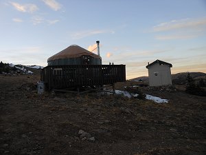
Finding the Marceline and Emma Yurts
back to topView and print a location map of the access route to Leadville Backcountry over Long & Derry Hill. You must have Adobe Acrobat Reader to view this map. Download the reader.
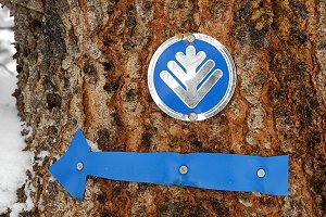
The trail is marked with blue circles with a silver tree in the middle. The private property signs refer to adjacent lands; please stay on the county roads that lead to the yurt as described below. Also, respect the multiuse trail, shared with skiers, snowmobilers and other recreationalists. In winter, plan to cover approximately one mile per hour. Leave early in the day.
Detailed directions from the trailhead to the Marceline and Emma Yurts
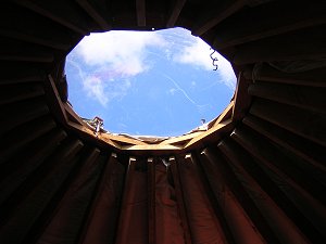
The yurts are located above treeline at 12,000 feet. The distance from the trailhead to the yurts is 5˝ miles with an elevation gain of 1,200 feet.
- Park at the Mt. Sherman trailhead parking. Head east on the paved road to the gate at the Blackcloud Mine.
- Follow the jeep road to your right downhill. Stay to your right past the Blackcloud Mine, on your left.
- Pass under the powerline. Pass a jeep road to your right. Stay on main jeep road heading left (east).
- Climb uphill. Pass under the powerline. Climb Long & Derry Hill - top on hill (1.0 miles)
- Heading south on the middle jeep road, traverse the meadow. You will see Mt. Massive to your right. THIS IS AN IMPORTANT JUNCTION, AS ONE ROAD GOES RIGHT, DOWNHILL, AND ONE ROAD GOES LEFT, UPHILL. Look for the post with a marker.
- A jeep road goes off to the left. Stay right on the main jeep road and begin a downhill descent, down Long & Derry Hill.
- Enter a clearcut area.
- The jeep road goes off to the right. Take this jeep road on your right for five tenths of a mile. This is a new road cut. This jeep road will intersect with a jeep road coming in on your right from Beaver Lakes Estates (this is private property). Mileage: 3 miles total; 2˝ miles further to the yurt site.
- Take a sharp left and cross a stream. Head uphill.
- Enter a meadow and follow the road to the far end of the meadow.
- Take a sharp LEFT marked with a post that indicates the direction. IMPORTANT TURN.
- Continue on jeep road uphill; first a gradual ascent; then climbs steeply.
- Reach green Forest Service gate.
- You will see cabin ruins on the right. On the left is Empire Reservoir.
- Head south up open valley to post and sign. Follow the edge of trees on your right.
- Reach Post—turn Right to yurts, uphill.
Total Mileage: 5˝ miles
Reverse Directions - Leaving the Yurts
back to top
- Note: In winter all gates should remain open. After a heavy snow the trail can look differently.
- From yurts travel to a post in the meadow, turn LEFT and pass between the cabin ruins on Left and Empire Reservoir on Right.
- Head downhill through a Forest Service gate.
- Continue on jeep road which descends steeply.
- Take a sharp RIGHT into meadow; marked with a post and follow road to far end of the meadow. Continue.
- Drop downhill and turn RIGHT. Cross a stream (You have gone 2 1/2 miles; continue 3 miles to trailhead.
- Head uphill through a marked intersection (Above and left is Beaver Lakes Estates; private Property). At top of hill turn Right.
- Continue on jeep road with a few homes on your Left. Enter clearcut area.
- Climb Long and Derry Hill and cross meadow at the top. Go across meadow.
- Begin long descent down a jeep road
- Pass under powerline
- Pass jeep road on LEFT. Turn Right and climb up to the Black Cloud Mine.
- Trailhead is up to the LEFT of the Black Cloud Mine.
The trail markers should be evident in both directions (Blue background with a silver tree)